
The Other Side of MLK Boulevard
In Baltimore, the road named for the slain civil rights icon brought suburbanites downtown—and displacement and isolation to the communities along its path.
It was May 2, 2015—two weeks after Freddie Gray had died of the spinal injury he received while in police custody, six days since swaths of Baltimore had erupted with rage.
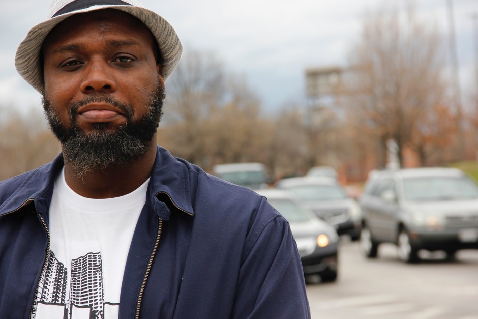
John Comer was driving by McCulloh Homes, the public housing complex where he had first started organizing for racial justice in Baltimore seven years ago with the local nonprofit Maryland Communities United.
There, he saw a row of armored Humvees with National Guardsmen peeking out from the roof—a jarring site on that bright blue cloud-speckled day. To get to the city’s northwest neighborhoods, where the unrest had been, the soldiers had driven up Martin Luther King, Jr. Boulevard and then turned the corner on McCulloh Street. It seemed sadly ironic to Comer that they’d taken a route named after the civil rights icon. It was almost as if they were trying to send a signal.
“A lot of residents said they hadn’t seen anything like that since MLK’s assassination,” he told me of the unrest that spring, as we stood on the corner of MLK and Franklin Street.
It was an octopus of an intersection, with MLK being the fattest tentacle, curling north-to-south through West Baltimore: Three lanes for southbound traffic, a vast median in the middle, and three for northbound traffic. On a Sunday afternoon, intermittent spurts of traffic pumped along the broad boulevard. Two high-school-age “squeegee boys” patrolled the stretch, working the three-wide line of cars at the red light to make a few dollars cleaning windshields. In shifts, panhandlers emerged from behind the supports holding up the U.S. 40 bridge, which carries motorists over MLK. We were about a 5 minute drive from where Freddie Gray used to live, and another 5 minutes from Baltimore’s heavily touristed Inner Harbor area.
The west side of MLK once held the Murphy Homes housing project, where Comer’s friend William Miller Jr., aka “Cornbread,” grew up. He’d been a squeegee boy himself, before he’d been arrested in 1996 on a violent charge, and spent 17 years in prison. The high-rise housing towers were demolished in 1999; in their place now stands a manicured cul-de-sac with a mixed-income development. But just a street or two behind it were blocks upon blocks of mostly vacant homes, burnt facades, and splintered doorways.
To the east of MLK, at a distance, we saw the backside of the University of Maryland, Baltimore campus, converted loft-style apartments, and downtown office towers. In the foreground was the Orchard Gardens apartments, a complex of a low-rise garden-style units—not a fancy building at all, but to Miller, it still seemed miles away from where he grew up.
“It's just the other side of the wall, you know,” Miller said. “Their parents had jobs; let’s just put it that way.”
***
At the University of Tennessee, geographer Derek Alderman has been keeping a running list of streets named after Martin Luther King Jr. since the late 1990s. In December 2017, he and his colleague Janna Caspersen counted 955 such roads in 41 states, D.C. and Puerto Rico. Not surprisingly, around 80 percent were in the South. Back in 2015, Alderman told me that based on a limited review of census data, a majority of these streets tended to be poor and segregated.
Baltimore’s Martin Luther King Jr. Boulevard is no outlier. It, too, signals the distance that still remains between King’s dream and the reality facing the communities that it runs through. But this street is not just a symbol: An approximately 1.5-mile long six-lane thoroughfare that curves around downtown Baltimore, it connects to Interstate 95 to the south and then re-joins the city’s older street grid just north of the city’s midpoint. It functions as a real, physical barrier between the mostly black residents in West Baltimore—households that are dealing with entrenched poverty, harsh policing, the effects of lead poisoning, and a spiking opioid addiction crisis—and the economic activity in the central spine of the city, located on the other side of the street. It’s a classic “border vacuum.”
“[Its name] belies the way in which the actual street itself is a primary marker of racial segregation in the city,” said Lawrence Brown, a professor at Morgan State University who studies the effects of displacement and disinvestment in black communities. “MLK Boulevard in Baltimore basically creates a boundary between the midtown/downtown area and then black West Baltimore.”
Below are two maps made for CityLab by location intelligence company ESRI. The first map shows the predominant racial group in census tracts alongside MLK Boulevard—the darker the color, the higher the share. The second shows at household income. The bright yellow line is Martin Luther King Jr. Boulevard.
As in so many U.S. cities, the street design of modern Baltimore reflects the racially charged decision-making that marked mid-20th century American life. Beginning in the 1930s, planners in Baltimore—a city skilled in pioneering “redlined” housing practices—started to devise a network of urban highways. The high-speed car routes would serve two purposes: One, get the growing ranks of white suburbanites to and from their downtown jobs as quickly as possible, and two, “slum clearance”—which often had more to do with the race of the people living in those areas than the quality of housing.
In 1957, the year President Dwight Eisenhower opened the floodgates of federal highway funding, Baltimore considered the following highway plan.

“They’re like, ‘Hurray, free money! We're going to build this highway—it’s going to be great,’” said Emily Lieb, a historian (and CityLab contributor) at the University of Seattle who’s writing a book about segregation in West Baltimore. “But the ‘we’ in this equation is always powerful, white people whose interests are downtown. [The city] tended to think a lot less about the other ‘we’ in the equation: ‘What is it going to cost us—the people who live here in the city of Baltimore.’”
The left arm of the highway’s inner loop in that 1957 plan tracks roughly with today’s MLK Boulevard: It runs through residential neighborhoods in West Baltimore, connecting a crossed pair of east-west and north-south Interstate highways. By then, thanks to public school construction and discriminatory housing policies, the mostly modest blocks of working-class rowhouses in West Baltimore were already intensely segregated, with the area’s Pennsylvania Avenue strip serving as the heart of the city’s black community.
That 1957 plan underwent many rounds of changes. In 1960, the city’s planning department released a new scheme that proposed running highways through some of the city’s most densely developed residential areas. Black and white Baltimoreans alike resisted these routes, but it was white—and politically connected—communities whose voices were heeded. The effect of this highway debate on the communities involved was destructive in itself. By the time the plan was finalized in 1969, many black neighborhoods—even the ones that didn’t ultimately have highways running through them—had got the message: They didn’t matter. Their homes could be condemned one day, and that condemnation could be revoked the next.
“So this [plan] was just another way of generating and perpetuating, number one, civic indifference, and number two, disinvestment in black neighborhoods.“ Lieb said.
What eventually got built was quite different than that 1957 plan, and even many of the iterations that followed. A modified version of Interstate 83 was built, but the highway stopped when it reached downtown, as community groups successfully resisted plans to extend it further, and the partially elevated expressways set to run along the city’s waterfront neighborhoods never materialized. The crosstown expressway dreamed of in 1957 also remained unfinished, though West Baltimore was ultimately carved up with the weirdly disconnected offshoot of I-70 known locally as the “Highway to Nowhere.”
Today’s MLK Boulevard represented the last piece of this somewhat haphazard puzzle, designed to help connect the threads of these unfinished urban expressways; it opened in 1982, as an at-grade high-speed thoroughfare named Harbor City Boulevard. Planning documents from 1978 called it “something more than a city street, but something less than an expressway.” Newspaper articles gushed that the street promised to be a much-needed addition to the web of highways bringing motorists in and out of downtown, and that it would help alleviate traffic in the “now-revitalized” areas of South and Southwest Baltimore. One Baltimore Sun piece from December, 1982 was particularly poetic:
A walk along the boulevard should convince Baltimoreans that the city is upgrading itself in sections other than the Inner Harbor. The walk isn’t just a study, though, for it progresses into a pleasant stroll that shows the present blending with the past, and offers a sense of rural tranquility at the edge of noisy bustle.
Later that year, black state legislators pushed through a resolution to rename the road after the civil rights icon whose death has set the city on fire a little more than a decade earlier. The city’s mayor, William Donald Schaefer, grumbled that the street signs with the original name had already been put up.
Collectively, the package of highways that MLK Boulevard joined made it easier for suburban motorists to zip to downtown and back without interacting with black Baltimoreans. By the time it opened, the city’s population was in mid-freefall, and the city had staked its economic hopes on downtown amenities like Harborplace, the pioneering festival marketplace that developer James Rouse opened in the Inner Harbor in 1980. The road’s construction also displaced black residents, worsening housing conditions in those areas. MLK Boulevard did not segregate the city by itself, but it did help make that segregation harder to undo, Lieb said.
When I relayed some of this history of the street to Comer, he wasn’t surprised. “For some, it can be a symbol of black pride,” he said. “But for others, depending on who’s granting access or granting opportunity for the name change, it’s just saying, ‘Here, take this. Be quiet. Be happy. Go away.’”
But, he added: “We are not the problems, we are only demonstrating symptoms of a problem, which have been policy, government, racism.”
***
MLK did do a good job moving cars in and out to city, and it still does. On an average rush hour—or before and after baseball and football games, as the road ends near the city’s two downtown stadiums—MLK swells with drivers using it to bypass downtown traffic or make for the northern suburbs. But it’s been far less successful in bringing investment to the communities trapped on its western side, for whom the road has functioned as a hard-to-penetrate border. Despite predictions that MLK would bring new life to these neighborhoods, it appears to have accomplished the opposite.
To bridge the divide it created, the city has lately tried a few things. One is to enlist the help of powerful institutions in its path, like the University of Maryland. In the past, the university had a pretty contentious relationship with the West Baltimore communities on its doorstep. But over the last few decades, it has undertaken several initiatives to help change that. Its most recent effort is the UM BioPark, a complex of research facilities, offices, and green space designed to bring jobs and related investments to the communities west of MLK.
This project is not without its critics. Local transit planner Gerald Neily, for example, has suggested that the university should have focused its place-making efforts on shrinking the massive footprint of MLK Boulevard. On the local news site Baltimore Brew in 2014, he recommended cutting down the street’s wide median and turning the road into a “series of active linear parks”—an amenity that could help stitch the troubled West Side back to the city.
Residents have their own distinct concerns. They’ve already seen the city demolish former public housing and enlist private developers to reshape the space, and feel that former residents don’t always get the opportunity to come back. The University of Maryland project evokes a familiar concern: that, like MLK Boulevard itself, the changes coming may not be for them; that the city and other powerful entities are still in charge of their fate; that if their neighborhoods do improve, it’s only because whiter, richer people or entities moved in.
“My concern about mixed-income communities is that I’ve seen them start off that way, but they don’t end up with low-income people still being able to stay,” Comer told me. “They don’t stay that way.”
It’s a familiar trap—and one that Martin Luther King Jr. would surely recognize.
This story is a collaboration between CityLab and NPR's Code Switch podcast. To hear episode, click here: